
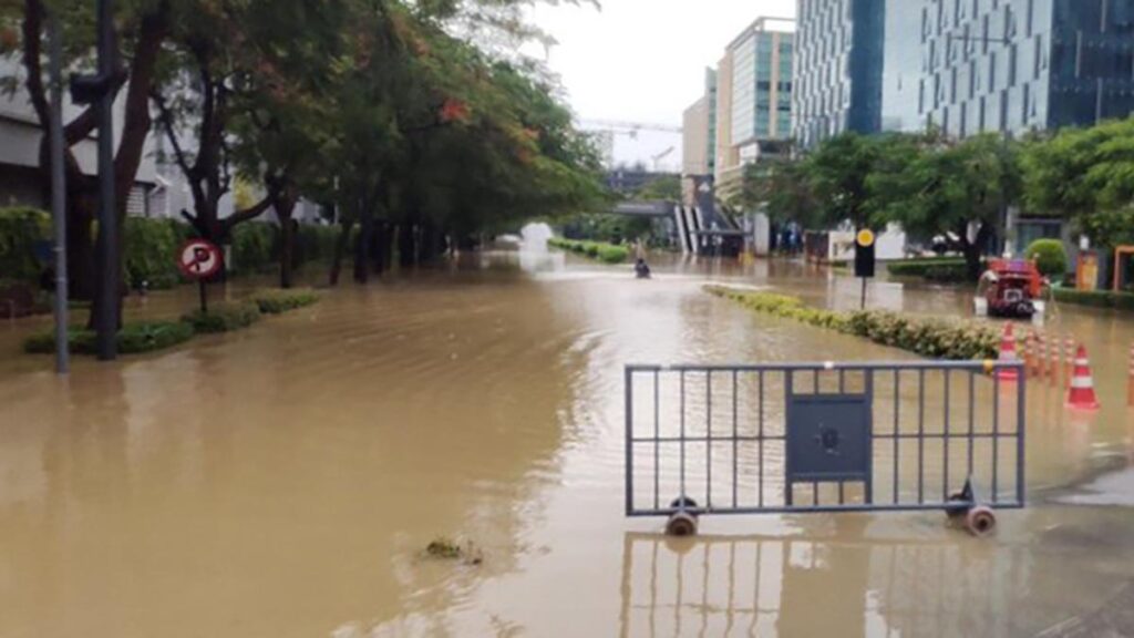
Flooding seen at Manyata Tech Park| Photo Credit: The Hindu
Manyata flooding: BBMP orders Manyata Tech Park, Ebisu to surrender land, build drains on own
Bengaluru
The Bruhat Bengaluru Mahanagara Palike (BBMP) has issued notices on June 12 ordering the prominent tech park developers and private landholders—including Manyata Promoters Pvt Ltd, Embassy Office Park REIT, and Ebisu Tech Park Pvt Ltd—to surrender land free of cost and take up the construction of crucial stormwater drains at their own expense in flood-prone Nagawara.
The notices were also sent to Karle Town Centre and Manpho. The notices were issued by by Zonal Commissioner, Yelahanka Zone.
The directive follows weeks of scrutiny after torrential rains on May 19 and 20 inundated key stretches around Manyata Tech Park and Outer Ring Road, severely disrupting movement and drawing public outrage. In the aftermath, the state’s top leadership, including the Chief Minister Siddaramaiah and Deputy Chief Minister and Bengaluru Development Minister, D K Shivakumar visited the affected sites. The situation prompted not only high-level government inspections but also a suo motu case initiated by the Lokayukta, who has since taken an active role in reviewing the matter.
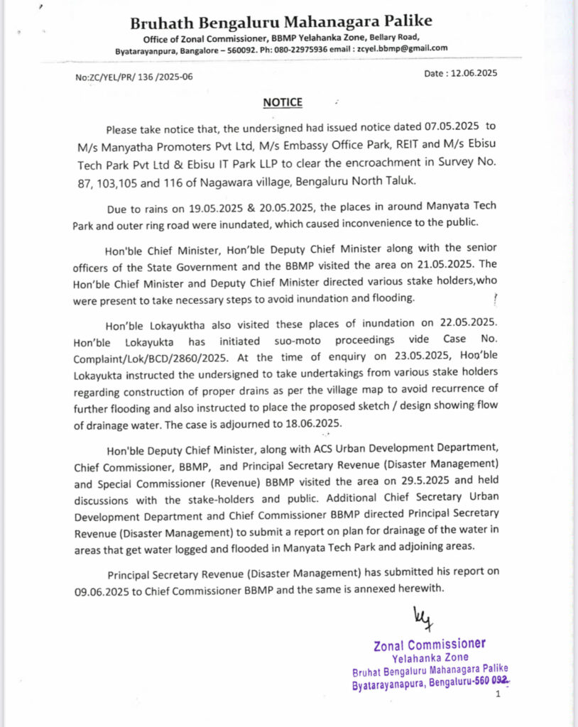
A report submitted on June 9, 2025, by the Principal Secretary of Revenue (Disaster Management) and BBMP Special Commissioner (Revenue), Munish Moudgil lays out the framework for long-term solutions to the flooding crisis. The report was prepared based on the 1958 revenue map and has not taken into account the 1885. map. The stakeholders who received the notice talking to BLR.POST said the report conveniently ignored old maps to allegedly favour Karle tech park.
Alleged encroachment
One of the stakeholders argued that Survey Number 91/3, through which the rajakaluve (stormwater drain) passes and classified as ‘B’ Kharab land, has allegedly been encroached upon by the Karle Group’s tech park project. Historical revenue records and maps from the lake authority indicate the presence of this stormwater drain across Survey Numbers 92/1, 92/2, 95/1, and 96/1 — all of which are also designated as ‘B’ Kharab land, a fact reflected even in their respective sale deeds.
On February 2, 2021, the then Deputy Commissioner of Bengaluru Urban allotted 0.27 gunta of ‘B’ Kharab land from Survey Numbers 92/1, 92/2, 95/1, and 96/1 to Karle Infrastructure Private Limited. However, this official order made no mention of Survey Number 91/3.
Contradictorily, a sale deed involving Karle and other parties records Survey Number 91/3 as measuring 36 guntas, along with an additional 0.9 gunta classified as ‘B’ Kharab. Moreover, revenue records (RTCs) from 1965 to 1986 consistently reflect this 0.9 gunta as ‘B’ Kharab. Curiously, this designation vanishes from the 1987 RTC without any formal order or notification from the Revenue Department — raising serious concerns over the legitimacy of land classification changes.
In simple words, A major cause of flooding in Nagawara is the disruption of the rajakaluve (stormwater drain) that originates from Sultanpalya. The 33-foot-wide drain abruptly narrows to just six feet and makes a sharp 90-degree turn near a Special Economic Zone (SEZ). Instead of flowing into the Mariyanna Palya bruhat kaluve (Nagawara Kere Kodi in Thanisandra) — the natural course visible on Google Maps until 2012 — the drain is diverted, causing water to overflow onto the Outer Ring Road (ORR) and surrounding properties. The drain comes to an abrupt end at the boundary of Karle’s property.
However, Munish Moudgil refuted the allegation saying that the 1958 map is the legally binding map and in the report he has mentioned about land grant to Karle Tech Park by the government.
Land grant to Karle is illegal
In the report it is also subtly mentioned that the land grant to Karle is illegal as the government cannot grant land-locked drains. The report said The pink coloured water drains in Sy No 92, 95 and 101 were land-locked drains as per the 1958 Nagavara Village map. As per the village map of Survey Department these were isolated within these Sy No and did not connect beyond these Sy Nos.
It is noted that as per the 1958 village map these isolated drains did not connect to the green coloured big rajakaluve on the north side nor to blue coloured water drain system in the south side. It is understood that these water drains have been sold to M/S Karle by the Government of Karnataka under section 69-A which was introduced as an amendment to the KLR Act 1964 in the year 2020 as Amending Act 44 of 2020. The definition of “Land Locked Government land” is in section 2 sub-section 14-A of the KLR Act 1964 which again was inserted by Amendment 44 of 2020. The construction thereon has been done by M/S Karle.
Recommendations in report
The BBMP, relying on the report, has now ordered that existing natural drains—documented in revenue maps—be restored and strengthened, and that new man-made drains be constructed across private properties wherever required. The catch: developers must part with the land for these drains without compensation and must fund the construction themselves.
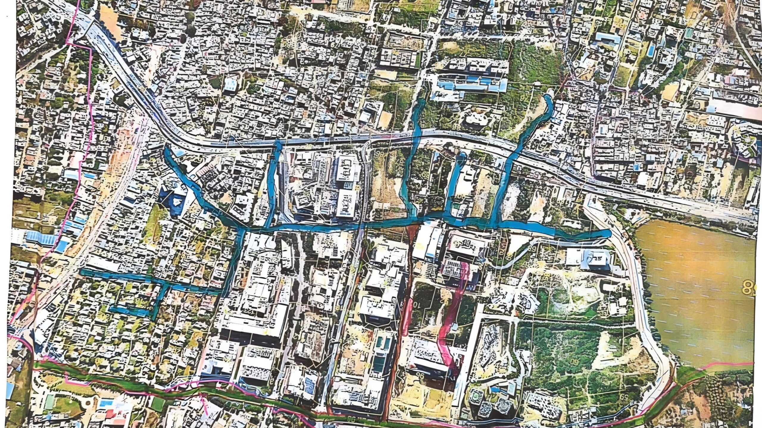
The report identifies several key measures. First, natural drains marked in Blue-Orange in village maps are to be made fully functional by following their original alignment. Where widening is needed, it must be done around the existing flow path, with land provided by private stakeholders. Secondly, new artificial drains shown in orange and orange-yellow are to be built to direct runoff into the main rajakaluve (major stormwater drain), even when such alignment passes through private tech parks.
BBMP has made it clear that infrastructure within Manyata Tech Park—including a stretch previously claimed by the park as unfit for drainage due to a slight upward gradient—must be altered to enable water to reach the deeper rajakaluve.
The BBMP has rejected Manyata’s argument that drainage construction is infeasible due to elevation changes. The report explains that although the terrain rises slightly over 500 meters, the receiving drain lies 15–20 feet lower, making it feasible for stormwater to flow effectively with the right engineering.
Equally notable is BBMP’s firm assertion that existing stormwater paths, as per revenue records, are sacrosanct. Planning authorities such as the KIADB are barred from altering them, and any construction on or diversion of these drains is prohibited.
Beyond the current crisis, the government has also issued a broader policy warning. Future building permissions—for layouts, tech parks, or commercial buildings—must include in-built drainage systems that connect to natural lakes or rajakaluves. The report attributes the worsening flood scenario to indiscriminate concretisation of farmland, which has stopped water from seeping into the ground and increased surface runoff. Without scientific planning and respect for natural water channels, Bengaluru’s infrastructure risks further collapse, the report cautions.
We have been living near Manyata tech Park from pastv25 yrs, we hsve seen how the land usage was modified & syorm wster drsins encroached upon, flooding hsppens every rsiny season, basements gets inundated , thst will be pumped on to the roads thus the entire tech park gets flooded,BBMP should also be penalised, for alllowing the situation to worsen….